


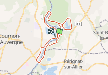
RIVIERE ALLIER DEPUIS BASE DE LOISIRS DE COURNON

DDESLAN
User

Length
8.9 km

Max alt
333 m

Uphill gradient
61 m
Km-Effort
9.7 km

Min alt
312 m

Downhill gradient
58 m
Boucle
Yes
Creation date :
2021-05-30 16:14:57.647
Updated on :
2021-05-30 16:20:38.904
2h12
Difficulty : Very easy

FREE GPS app for hiking
 SityTrail
IGN / Geographical institutes
SityTrail Plus
The world is yours!
About
Trail Walking of 8.9 km to be discovered at Auvergne-Rhône-Alpes, Puy-de-Dôme, Cournon-d'Auvergne. This trail is proposed by DDESLAN.
Positioning
Country:
France
Region :
Auvergne-Rhône-Alpes
Department/Province :
Puy-de-Dôme
Municipality :
Cournon-d'Auvergne
Location:
Unknown
Start:(Dec)
Start:(UTM)
517320 ; 5065118 (31T) N.
Comments