


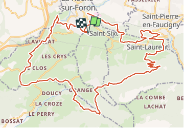
Saint Sixt - Mont Piton

HG74250
User

Length
35 km

Max alt
1195 m

Uphill gradient
914 m
Km-Effort
47 km

Min alt
539 m

Downhill gradient
910 m
Boucle
Yes
Creation date :
2021-05-30 19:01:22.968
Updated on :
2021-05-31 05:28:17.024
3h34
Difficulty : Very difficult

FREE GPS app for hiking
 SityTrail
IGN / Geographical institutes
SityTrail Plus
The world is yours!
About
Trail Mountain bike of 35 km to be discovered at Auvergne-Rhône-Alpes, Upper Savoy, Saint-Sixt. This trail is proposed by HG74250.
Description
un single technique pour commencer, une montée à Orange assez cool, une superbe descente le long du Foron
Positioning
Country:
France
Region :
Auvergne-Rhône-Alpes
Department/Province :
Upper Savoy
Municipality :
Saint-Sixt
Location:
Unknown
Start:(Dec)
Start:(UTM)
292604 ; 5103435 (32T) N.
Comments