


VALENCIN 16.06.21

6ARVAL7
User
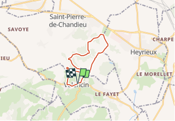

Length
11 km

Max alt
366 m

Uphill gradient
251 m
Km-Effort
14.3 km

Min alt
273 m

Downhill gradient
249 m
Boucle
Yes
Creation date :
2021-05-31 16:53:39.255
Updated on :
2021-05-31 16:54:36.207
3h15
Difficulty : Difficult

FREE GPS app for hiking
 SityTrail
IGN / Geographical institutes
SityTrail Plus
The world is yours!
About
Trail Walking of 11 km to be discovered at Auvergne-Rhône-Alpes, Isère, Valencin. This trail is proposed by 6ARVAL7.
Positioning
Country:
France
Region :
Auvergne-Rhône-Alpes
Department/Province :
Isère
Municipality :
Valencin
Location:
Unknown
Start:(Dec)
Start:(UTM)
657284 ; 5053037 (31T) N.
Comments