


Aqueduc, vue sur les Alpes et Madone depuis Yzeron

trietsch
User
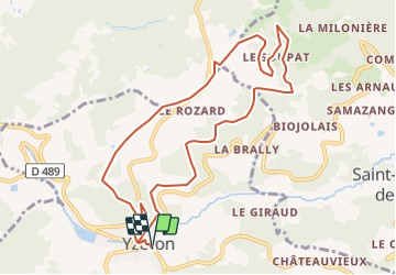

Length
10.5 km

Max alt
857 m

Uphill gradient
318 m
Km-Effort
14.7 km

Min alt
661 m

Downhill gradient
318 m
Boucle
Yes
Creation date :
2021-05-31 17:49:37.961
Updated on :
2021-07-18 06:31:54.543
3h20
Difficulty : Difficult

FREE GPS app for hiking
 SityTrail
IGN / Geographical institutes
SityTrail Plus
The world is yours!
About
Trail Walking of 10.5 km to be discovered at Auvergne-Rhône-Alpes, Rhône, Yzeron. This trail is proposed by trietsch.
Points of interest


Positioning
Country:
France
Region :
Auvergne-Rhône-Alpes
Department/Province :
Rhône
Municipality :
Yzeron
Location:
Unknown
Start:(Dec)
Start:(UTM)
623868 ; 5062761 (31T) N.
Comments