


ventabren.canal.alain

NADINE52
User
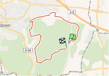

Length
8.5 km

Max alt
227 m

Uphill gradient
120 m
Km-Effort
10.1 km

Min alt
159 m

Downhill gradient
111 m
Boucle
Yes
Creation date :
2021-06-01 08:37:52.063
Updated on :
2021-06-01 12:34:09.606
2h12
Difficulty : Medium

FREE GPS app for hiking
 SityTrail
IGN / Geographical institutes
SityTrail Plus
The world is yours!
About
Trail Walking of 8.5 km to be discovered at Provence-Alpes-Côte d'Azur, Bouches-du-Rhône, Ventabren. This trail is proposed by NADINE52.
Photos

Positioning
Country:
France
Region :
Provence-Alpes-Côte d'Azur
Department/Province :
Bouches-du-Rhône
Municipality :
Ventabren
Location:
Unknown
Start:(Dec)
Start:(UTM)
688440 ; 4822426 (31T) N.
Comments