


montagne-de-pélegrine-modifiée-fait

RobinMicheline
User GUIDE
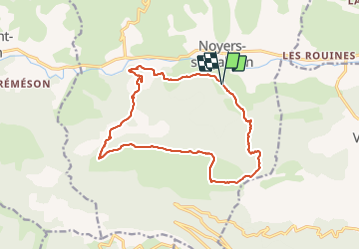

Length
16.8 km

Max alt
1350 m

Uphill gradient
871 m
Km-Effort
28 km

Min alt
582 m

Downhill gradient
869 m
Boucle
Yes
Creation date :
2021-06-01 14:06:57.382
Updated on :
2021-06-03 07:01:42.161
6h27
Difficulty : Medium

FREE GPS app for hiking
 SityTrail
IGN / Geographical institutes
SityTrail Plus
The world is yours!
About
Trail On foot of 16.8 km to be discovered at Provence-Alpes-Côte d'Azur, Alpes-de-Haute-Provence, Noyers-sur-Jabron. This trail is proposed by RobinMicheline.
Positioning
Country:
France
Region :
Provence-Alpes-Côte d'Azur
Department/Province :
Alpes-de-Haute-Provence
Municipality :
Noyers-sur-Jabron
Location:
Unknown
Start:(Dec)
Start:(UTM)
726174 ; 4893630 (31T) N.
Comments