


Vercors Sentier Gobert et Col Vert

c.gourme
User
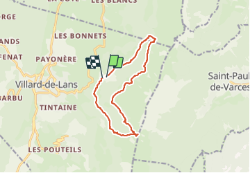

Length
13.7 km

Max alt
1746 m

Uphill gradient
664 m
Km-Effort
23 km

Min alt
1163 m

Downhill gradient
686 m
Boucle
Yes
Creation date :
2021-06-01 08:51:12.0
Updated on :
2021-06-01 15:01:08.909
5h47
Difficulty : Medium

FREE GPS app for hiking
 SityTrail
IGN / Geographical institutes
SityTrail Plus
The world is yours!
About
Trail Walking of 13.7 km to be discovered at Auvergne-Rhône-Alpes, Isère, Villard-de-Lans. This trail is proposed by c.gourme.
Description
Réfléchir ds quel sens le faire : parking col vert 2 h / 1h en descente
Positioning
Country:
France
Region :
Auvergne-Rhône-Alpes
Department/Province :
Isère
Municipality :
Villard-de-Lans
Location:
Unknown
Start:(Dec)
Start:(UTM)
703187 ; 4994305 (31T) N.
Comments