


pic du cap roux

gerardmicheline
User
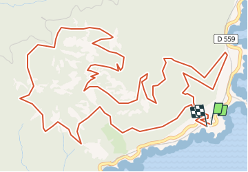

Length
10.5 km

Max alt
440 m

Uphill gradient
576 m
Km-Effort
18.2 km

Min alt
27 m

Downhill gradient
582 m
Boucle
Yes
Creation date :
2021-06-01 16:06:58.352
Updated on :
2021-06-01 16:07:03.587
4h07
Difficulty : Difficult

FREE GPS app for hiking
 SityTrail
IGN / Geographical institutes
SityTrail Plus
The world is yours!
About
Trail Walking of 10.5 km to be discovered at Provence-Alpes-Côte d'Azur, Var, Saint-Raphaël. This trail is proposed by gerardmicheline.
Positioning
Country:
France
Region :
Provence-Alpes-Côte d'Azur
Department/Province :
Var
Municipality :
Saint-Raphaël
Location:
Unknown
Start:(Dec)
Start:(UTM)
331513 ; 4812836 (32T) N.
Comments