


GORGE DES ROITELETS

surceneux
User
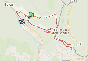

Length
6.2 km

Max alt
773 m

Uphill gradient
213 m
Km-Effort
9.1 km

Min alt
617 m

Downhill gradient
217 m
Boucle
Yes
Creation date :
2021-06-01 13:39:44.87
Updated on :
2021-06-01 17:11:04.13
1h50
Difficulty : Medium

FREE GPS app for hiking
 SityTrail
IGN / Geographical institutes
SityTrail Plus
The world is yours!
About
Trail Walking of 6.2 km to be discovered at Grand Est, Vosges, Gérardmer. This trail is proposed by surceneux.
Description
KICHOMPRE CENTRE BASSE DE L'OURS LA GLACIERE GRANGE DU CHENY GORGES DES ROITELETS LES VANNES PONT DES FEES KICHOMPRE
Positioning
Country:
France
Region :
Grand Est
Department/Province :
Vosges
Municipality :
Gérardmer
Location:
Unknown
Start:(Dec)
Start:(UTM)
342703 ; 5328738 (32U) N.
Comments