


Autour du site de là tarente

jmbilger
User
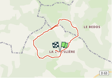

Length
7.8 km

Max alt
1008 m

Uphill gradient
168 m
Km-Effort
10.1 km

Min alt
928 m

Downhill gradient
171 m
Boucle
Yes
Creation date :
2021-06-02 08:34:08.0
Updated on :
2021-06-02 11:02:23.685
2h27
Difficulty : Medium

FREE GPS app for hiking
 SityTrail
IGN / Geographical institutes
SityTrail Plus
The world is yours!
About
Trail Walking of 7.8 km to be discovered at Occitania, Lozère, Saint-Pierre-des-Tripiers. This trail is proposed by jmbilger.
Positioning
Country:
France
Region :
Occitania
Department/Province :
Lozère
Municipality :
Saint-Pierre-des-Tripiers
Location:
Unknown
Start:(Dec)
Start:(UTM)
523857 ; 4899305 (31T) N.
Comments