


Herbelon- sous cote Rouge pt 910 G3

rolland-a
User
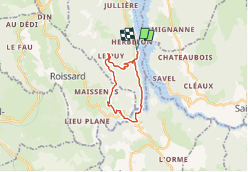

Length
10.5 km

Max alt
917 m

Uphill gradient
560 m
Km-Effort
18 km

Min alt
487 m

Downhill gradient
560 m
Boucle
Yes
Creation date :
2021-06-02 19:04:22.896
Updated on :
2021-06-02 20:53:57.397
4h05
Difficulty : Easy
4h05
Difficulty : Difficult

FREE GPS app for hiking
 SityTrail
IGN / Geographical institutes
SityTrail Plus
The world is yours!
About
Trail On foot of 10.5 km to be discovered at Auvergne-Rhône-Alpes, Isère, Treffort. This trail is proposed by rolland-a.
Positioning
Country:
France
Region :
Auvergne-Rhône-Alpes
Department/Province :
Isère
Municipality :
Treffort
Location:
Unknown
Start:(Dec)
Start:(UTM)
711216 ; 4974535 (31T) N.
Comments