


Loire sur Rhône 8.4 à 262

jtraverse
User
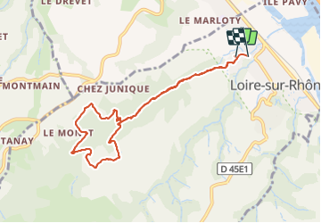

Length
8.6 km

Max alt
365 m

Uphill gradient
257 m
Km-Effort
12.1 km

Min alt
162 m

Downhill gradient
272 m
Boucle
Yes
Creation date :
2021-06-03 10:55:37.629
Updated on :
2021-06-03 13:45:37.261
2h48
Difficulty : Medium

FREE GPS app for hiking
 SityTrail
IGN / Geographical institutes
SityTrail Plus
The world is yours!
About
Trail Walking of 8.6 km to be discovered at Auvergne-Rhône-Alpes, Rhône, Loire-sur-Rhône. This trail is proposed by jtraverse.
Description
4 z
Positioning
Country:
France
Region :
Auvergne-Rhône-Alpes
Department/Province :
Rhône
Municipality :
Loire-sur-Rhône
Location:
Unknown
Start:(Dec)
Start:(UTM)
640308 ; 5047044 (31T) N.
Comments