


cap esterel

sacadostcv
User
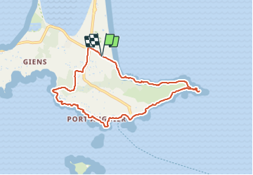

Length
8.9 km

Max alt
57 m

Uphill gradient
141 m
Km-Effort
10.8 km

Min alt
0 m

Downhill gradient
139 m
Boucle
Yes
Creation date :
2021-06-03 07:41:52.77
Updated on :
2021-06-03 14:55:28.769
3h01
Difficulty : Medium

FREE GPS app for hiking
 SityTrail
IGN / Geographical institutes
SityTrail Plus
The world is yours!
About
Trail Walking of 8.9 km to be discovered at Provence-Alpes-Côte d'Azur, Var, Hyères. This trail is proposed by sacadostcv.
Positioning
Country:
France
Region :
Provence-Alpes-Côte d'Azur
Department/Province :
Var
Municipality :
Hyères
Location:
Unknown
Start:(Dec)
Start:(UTM)
267715 ; 4769109 (32T) N.
Comments