


20210603 Nolleval

Childebert
User
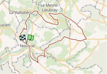

Length
20 km

Max alt
226 m

Uphill gradient
417 m
Km-Effort
26 km

Min alt
84 m

Downhill gradient
418 m
Boucle
Yes
Creation date :
2021-06-03 07:19:12.978
Updated on :
2021-06-03 16:14:03.899
6h41
Difficulty : Medium

FREE GPS app for hiking
 SityTrail
IGN / Geographical institutes
SityTrail Plus
The world is yours!
About
Trail Walking of 20 km to be discovered at Normandy, Seine-Maritime, Nolléval. This trail is proposed by Childebert.
Positioning
Country:
France
Region :
Normandy
Department/Province :
Seine-Maritime
Municipality :
Nolléval
Location:
Unknown
Start:(Dec)
Start:(UTM)
389938 ; 5483497 (31U) N.
Comments