
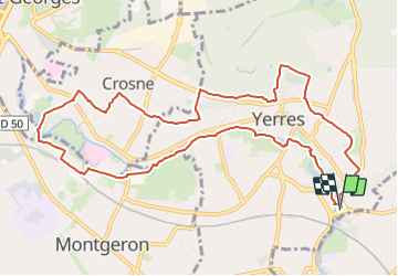
J 43 Yerres Parc Caillebotte, île des Prévôts

Les 1000 pattes
Club randonnées SERVON


2h59
Difficulty : Medium

FREE GPS app for hiking
 SityTrail
IGN / Geographical institutes
SityTrail Plus
The world is yours!
About
Trail Walking of 11.4 km to be discovered at Ile-de-France, Essonne, Yerres. This trail is proposed by Les 1000 pattes.
Description
Parking des 2 Rivières à Yerres près du Mac Do
Rond point de la Rue Raymond Poincaré à Yerres et la Rue de Villecresnes à Brunoy
Trajet Servon-->Yerres: 12km
Photos

Positioning
Comments