


portes chatelard1

parastat
User
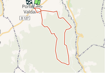

Length
8.2 km

Max alt
441 m

Uphill gradient
255 m
Km-Effort
11.6 km

Min alt
225 m

Downhill gradient
255 m
Boucle
Yes
Creation date :
2021-06-04 06:13:09.072
Updated on :
2021-06-04 06:19:34.696
2h37
Difficulty : Medium

FREE GPS app for hiking
 SityTrail
IGN / Geographical institutes
SityTrail Plus
The world is yours!
About
Trail Walking of 8.2 km to be discovered at Auvergne-Rhône-Alpes, Drôme, Portes-en-Valdaine. This trail is proposed by parastat.
Positioning
Country:
France
Region :
Auvergne-Rhône-Alpes
Department/Province :
Drôme
Municipality :
Portes-en-Valdaine
Location:
Unknown
Start:(Dec)
Start:(UTM)
651887 ; 4932449 (31T) N.
Comments