


Rocher Lajas BF rando novembre 2021 + 629

claude nier
User
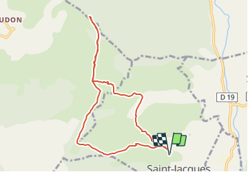

Length
9.2 km

Max alt
1479 m

Uphill gradient
629 m
Km-Effort
17.6 km

Min alt
862 m

Downhill gradient
630 m
Boucle
Yes
Creation date :
2021-06-05 12:32:26.518
Updated on :
2021-06-05 12:35:36.859
4h00
Difficulty : Easy

FREE GPS app for hiking
 SityTrail
IGN / Geographical institutes
SityTrail Plus
The world is yours!
About
Trail On foot of 9.2 km to be discovered at Provence-Alpes-Côte d'Azur, Alpes-de-Haute-Provence, Saint-Jacques. This trail is proposed by claude nier.
Description
depart 862 mts
arrivee 1479 mts
629 mts
non accidente
Positioning
Country:
France
Region :
Provence-Alpes-Côte d'Azur
Department/Province :
Alpes-de-Haute-Provence
Municipality :
Saint-Jacques
Location:
Unknown
Start:(Dec)
Start:(UTM)
289350 ; 4872042 (32T) N.
Comments