


Céda

adamfv
User
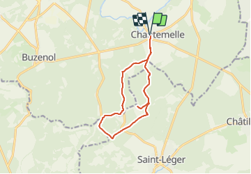

Length
11.3 km

Max alt
363 m

Uphill gradient
211 m
Km-Effort
14.1 km

Min alt
265 m

Downhill gradient
211 m
Boucle
Yes
Creation date :
2021-06-05 13:45:36.0
Updated on :
2021-06-05 16:25:27.489
2h13
Difficulty : Unknown

FREE GPS app for hiking
 SityTrail
IGN / Geographical institutes
SityTrail Plus
The world is yours!
About
Trail Walking of 11.3 km to be discovered at Wallonia, Luxembourg, Étalle. This trail is proposed by adamfv.
Positioning
Country:
Belgium
Region :
Wallonia
Department/Province :
Luxembourg
Municipality :
Étalle
Location:
Chantemelle
Start:(Dec)
Start:(UTM)
691382 ; 5503454 (31U) N.
Comments