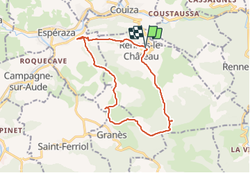
Trail Walking Rennes-le-Château - Rennes le Chateau - Photo
 PI11
PI11

User

© OpenStreetMap contributors
Length
Length
15.6 km
Max alt
Max alt
523 m
Uphill gradient
Uphill gradient
507 m
Km-Effort
Km-Effort  
22 km
Min alt
Min alt
250 m
Downhill gradient
Downhill gradient
509 m
Boucle
Boucle
Yes
Creation date :
2021-06-05 07:59:29.037
Updated on :
2021-06-06 13:47:07.432

(0 Reviews)

Walking
Walking
5h26
Difficulty : Easy

Scan this QR Code to open this trail in the SityTrail application

FREE GPS app for hiking

Logo SityTrail SityTrail

IGN / Geographical institutes

Download SityTrail from the App Store Download SityTrail from Google Play

Logo SityTrail SityTrail Plus

The world is yours!

Download SityTrail from the App Store Download SityTrail from Google Play Download SityTrail on Huawei AppGallery

About

Trail Walking of 15.6 km to be discovered at Occitania, Aude, Rennes-le-Château. This trail is proposed by PI11.

Description

Circuit départ à Rennes le Chateau en passant aux abord d'Espéraza et de Granès.
Vue impressionnante sur le mont Bugarach et quelques crètes rocheuses sorties de nul part ainsi que les rocs de l'aigle où l'on a pu admirer le vol d'un aigle ou d'un vautour…

Elevation profile

Photos

Positioning

Country:
France
Region :
Occitania
Department/Province :
Aude
Municipality :
Rennes-le-Château
Location:
Unknown
Start:(UTM)
440013 ; 4753093 (31T) N.


Close
My subscriptions