


randogps49-216

MarcBoscher
User
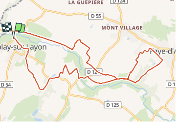

Length
12.5 km

Max alt
93 m

Uphill gradient
197 m
Km-Effort
15.2 km

Min alt
23 m

Downhill gradient
197 m
Boucle
Yes
Creation date :
2021-06-06 08:44:42.797
Updated on :
2022-02-25 13:30:02.978
3h26
Difficulty : Medium

FREE GPS app for hiking
 SityTrail
IGN / Geographical institutes
SityTrail Plus
The world is yours!
About
Trail Walking of 12.5 km to be discovered at Pays de la Loire, Maine-et-Loire, Bellevigne-en-Layon. This trail is proposed by MarcBoscher.
Description
Entre Rablay dur layon et Faye d'Anjou. Belle randonnée variée, et de jolis points de vue sur les coteaux du Layon.

Positioning
Country:
France
Region :
Pays de la Loire
Department/Province :
Maine-et-Loire
Municipality :
Bellevigne-en-Layon
Location:
Unknown
Start:(Dec)
Start:(UTM)
683136 ; 5241015 (30T) N.
Comments