


TMB 10 - Tré le Champ -> Chamonix

uru2010
User
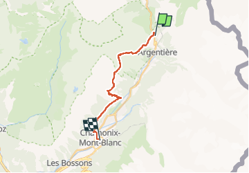

Length
15.9 km

Max alt
2359 m

Uphill gradient
1109 m
Km-Effort
32 km

Min alt
1038 m

Downhill gradient
1470 m
Boucle
No
Creation date :
2021-06-06 09:23:25.07
Updated on :
2022-05-08 15:05:41.356
7h30
Difficulty : Very difficult
FREE GPS app for hiking
 SityTrail
IGN / Geographical institutes
SityTrail Plus
The world is yours!
About
Trail Walking of 15.9 km to be discovered at Auvergne-Rhône-Alpes, Upper Savoy, Chamonix-Mont-Blanc. This trail is proposed by uru2010.
Description
Départ : Auberge La Boerne, Tréléchamps.
Arrivée : Hôtel Gustavia, 272 avenue Michel Croz, Chamonix. Tél : 04 50 53 00 31.
Durée selon le guide : 7h30.

Positioning
Country:
France
Region :
Auvergne-Rhône-Alpes
Department/Province :
Upper Savoy
Municipality :
Chamonix-Mont-Blanc
Location:
Unknown
Start:(Dec)
Start:(UTM)
339517 ; 5095581 (32T) N.
Comments