


Lantignié (14 km - D. 425 m)

Thomasdanielle
User
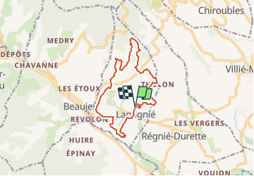

Length
13.9 km

Max alt
626 m

Uphill gradient
425 m
Km-Effort
19.6 km

Min alt
265 m

Downhill gradient
426 m
Boucle
Yes
Creation date :
2021-06-06 07:47:12.0
Updated on :
2021-08-21 09:40:34.675
4h13
Difficulty : Very difficult

FREE GPS app for hiking
 SityTrail
IGN / Geographical institutes
SityTrail Plus
The world is yours!
About
Trail Walking of 13.9 km to be discovered at Auvergne-Rhône-Alpes, Rhône, Lantignié. This trail is proposed by Thomasdanielle.
Description
D/A Parking Eglise
Positioning
Country:
France
Region :
Auvergne-Rhône-Alpes
Department/Province :
Rhône
Municipality :
Lantignié
Location:
Unknown
Start:(Dec)
Start:(UTM)
625360 ; 5111743 (31T) N.
Comments