


Source de l Aubette Bis

Fky78
User
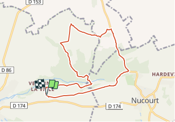

Length
8.8 km

Max alt
128 m

Uphill gradient
107 m
Km-Effort
10.2 km

Min alt
85 m

Downhill gradient
114 m
Boucle
Yes
Creation date :
2021-06-06 15:15:05.873
Updated on :
2021-06-07 16:12:40.536
1h23
Difficulty : Medium

FREE GPS app for hiking
 SityTrail
IGN / Geographical institutes
SityTrail Plus
The world is yours!
About
Trail Walking of 8.8 km to be discovered at Ile-de-France, Val-d'Oise, Magny-en-Vexin. This trail is proposed by Fky78.
Description
à faire pas temps sec un passage pouvant être bien humide
Photos

Positioning
Country:
France
Region :
Ile-de-France
Department/Province :
Val-d'Oise
Municipality :
Magny-en-Vexin
Location:
Unknown
Start:(Dec)
Start:(UTM)
413884 ; 5445869 (31U) N.
Comments