


courcelle 18 km

les randos d'Olivier
partout a pied et en moto
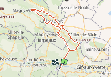

Length
17.9 km

Max alt
168 m

Uphill gradient
409 m
Km-Effort
23 km

Min alt
69 m

Downhill gradient
409 m
Boucle
Yes
Creation date :
2021-06-07 13:20:02.797
Updated on :
2021-06-07 13:30:16.238
3h51
Difficulty : Difficult

FREE GPS app for hiking
 SityTrail
IGN / Geographical institutes
SityTrail Plus
The world is yours!
About
Trail Walking of 17.9 km to be discovered at Ile-de-France, Essonne, Gif-sur-Yvette. This trail is proposed by les randos d'Olivier.
Positioning
Country:
France
Region :
Ile-de-France
Department/Province :
Essonne
Municipality :
Gif-sur-Yvette
Location:
Unknown
Start:(Dec)
Start:(UTM)
433741 ; 5394604 (31U) N.
Comments