


Louet RS lac2021

LouisROGER
User GUIDE
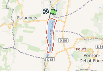

Length
4.1 km

Max alt
343 m

Uphill gradient
52 m
Km-Effort
4.8 km

Min alt
318 m

Downhill gradient
55 m
Boucle
Yes
Creation date :
2021-06-08 12:17:17.808
Updated on :
2021-06-08 14:13:06.206
1h54
Difficulty : Easy

FREE GPS app for hiking
 SityTrail
IGN / Geographical institutes
SityTrail Plus
The world is yours!
About
Trail Walking of 4.1 km to be discovered at Occitania, Hautespyrenees, Escaunets. This trail is proposed by LouisROGER.
Positioning
Country:
France
Region :
Occitania
Department/Province :
Hautespyrenees
Municipality :
Escaunets
Location:
Unknown
Start:(Dec)
Start:(UTM)
737812 ; 4803506 (30T) N.
Comments