


gages

bouscaillou
User

Length
9 km

Max alt
657 m

Uphill gradient
168 m
Km-Effort
11.2 km

Min alt
570 m

Downhill gradient
166 m
Boucle
Yes
Creation date :
2021-06-08 12:11:20.165
Updated on :
2021-06-08 14:48:25.662
2h35
Difficulty : Very easy

FREE GPS app for hiking
 SityTrail
IGN / Geographical institutes
SityTrail Plus
The world is yours!
About
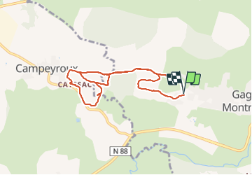
Trail Nordic walking of 9 km to be discovered at Occitania, Aveyron, Montrozier. This trail is proposed by bouscaillou.
Positioning
Country:
France
Region :
Occitania
Department/Province :
Aveyron
Municipality :
Montrozier
Location:
Unknown
Start:(Dec)
Start:(UTM)
475258 ; 4916190 (31T) N.
Comments