


crouy2

Yannick.Boireau
User

Length
13.6 km

Max alt
90 m

Uphill gradient
65 m
Km-Effort
14.5 km

Min alt
71 m

Downhill gradient
54 m
Boucle
No
Creation date :
2021-06-08 13:19:08.876
Updated on :
2021-06-08 18:19:40.489
3h31
Difficulty : Difficult

FREE GPS app for hiking
 SityTrail
IGN / Geographical institutes
SityTrail Plus
The world is yours!
About
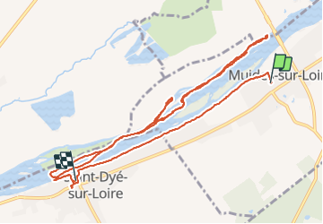
Trail Walking of 13.6 km to be discovered at Centre-Loire Valley, Loir-et-Cher, Muides-sur-Loire. This trail is proposed by Yannick.Boireau.
Positioning
Country:
France
Region :
Centre-Loire Valley
Department/Province :
Loir-et-Cher
Municipality :
Muides-sur-Loire
Location:
Unknown
Start:(Dec)
Start:(UTM)
389301 ; 5280538 (31T) N.
Comments