


Wikiloc - GR®70 Chemin de Stevenson (2021)

Franck2148
User
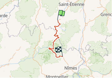

Length
275 km

Max alt
1699 m

Uphill gradient
8041 m
Km-Effort
384 km

Min alt
127 m

Downhill gradient
8541 m
Boucle
No
Creation date :
2021-06-09 09:14:49.401
Updated on :
2021-06-09 09:15:50.799
26h38
Difficulty : Very difficult

FREE GPS app for hiking
 SityTrail
IGN / Geographical institutes
SityTrail Plus
The world is yours!
About
Trail Mountain bike of 275 km to be discovered at Auvergne-Rhône-Alpes, Haute-Loire, Le Puy-en-Velay. This trail is proposed by Franck2148.
Positioning
Country:
France
Region :
Auvergne-Rhône-Alpes
Department/Province :
Haute-Loire
Municipality :
Le Puy-en-Velay
Location:
Unknown
Start:(Dec)
Start:(UTM)
569713 ; 4988176 (31T) N.
Comments