


balade 10 juin

gilbertdu60
User

Length
18.9 km

Max alt
147 m

Uphill gradient
234 m
Km-Effort
22 km

Min alt
26 m

Downhill gradient
234 m
Boucle
Yes
Creation date :
2021-06-11 12:30:02.741
Updated on :
2021-06-11 16:20:59.228
1h45
Difficulty : Easy

FREE GPS app for hiking
 SityTrail
IGN / Geographical institutes
SityTrail Plus
The world is yours!
About
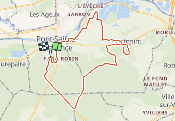
Trail Electric bike of 18.9 km to be discovered at Hauts-de-France, Oise, Pont-Sainte-Maxence. This trail is proposed by gilbertdu60.
Description
vers Pontpoint, par les sentiers campagnards et les sentiers de forêt
Positioning
Country:
France
Region :
Hauts-de-France
Department/Province :
Oise
Municipality :
Pont-Sainte-Maxence
Location:
Unknown
Start:(Dec)
Start:(UTM)
470912 ; 5460279 (31U) N.
Comments