


ST JACQUES

surceneux
User
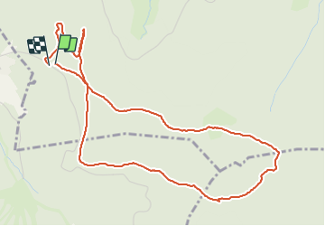

Length
5.5 km

Max alt
1093 m

Uphill gradient
125 m
Km-Effort
7.2 km

Min alt
1002 m

Downhill gradient
129 m
Boucle
Yes
Creation date :
2021-06-12 09:24:08.565
Updated on :
2021-06-12 17:38:45.207
1h15
Difficulty : Very easy

FREE GPS app for hiking
 SityTrail
IGN / Geographical institutes
SityTrail Plus
The world is yours!
About
Trail Walking of 5.5 km to be discovered at Grand Est, Vosges, Xonrupt-Longemer. This trail is proposed by surceneux.
Description
FONTAINE FERRY ST JACQUES BOUCLE PISTES FOND
Positioning
Country:
France
Region :
Grand Est
Department/Province :
Vosges
Municipality :
Xonrupt-Longemer
Location:
Unknown
Start:(Dec)
Start:(UTM)
344625 ; 5325429 (32U) N.
Comments