


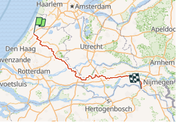
Zuid-Holland - Land van Rijn tot Maas

gpstracks
User

Length
141 km

Max alt
16 m

Uphill gradient
518 m
Km-Effort
148 km

Min alt
-7 m

Downhill gradient
512 m
Boucle
No
Creation date :
2014-12-10 00:00:00.0
Updated on :
2014-12-10 00:00:00.0
--
Difficulty : Unknown

FREE GPS app for hiking
 SityTrail
IGN / Geographical institutes
SityTrail Plus
The world is yours!
About
Trail Cycle of 141 km to be discovered at South Holland, Unknown, Oegstgeest. This trail is proposed by gpstracks.
Description
More information on GPStracks.nl : http://www.gpstracks.nl


Positioning
Country:
Netherlands
Region :
South Holland
Department/Province :
Unknown
Municipality :
Oegstgeest
Location:
Unknown
Start:(Dec)
Start:(UTM)
600222 ; 5782716 (31U) N.
Comments