


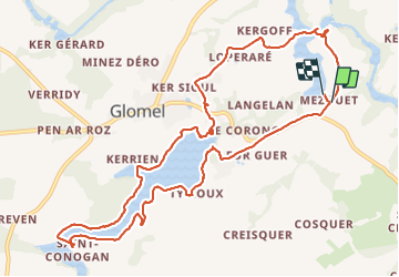
Tour de l'etang du Corong depuis Mézouët

Claudele
User

Length
12 km

Max alt
245 m

Uphill gradient
139 m
Km-Effort
13.9 km

Min alt
187 m

Downhill gradient
145 m
Boucle
Yes
Creation date :
2021-06-14 08:08:20.204
Updated on :
2021-06-14 13:48:51.344
4h49
Difficulty : Easy

FREE GPS app for hiking
 SityTrail
IGN / Geographical institutes
SityTrail Plus
The world is yours!
About
Trail Walking of 12 km to be discovered at Brittany, Côtes-d'Armor, Glomel. This trail is proposed by Claudele.
Photos


33 photos in total. Please click on a photo to see them all in the gallery.
Positioning
Country:
France
Region :
Brittany
Department/Province :
Côtes-d'Armor
Municipality :
Glomel
Location:
Unknown
Start:(Dec)
Start:(UTM)
472715 ; 5341191 (30U) N.
Comments