Trail Walking Aspremont - Aspremont tour du Mont Chauve, montée au fort. - Photo

Aspremont tour du Mont Chauve, montée au fort.

 jll7513
jll7513

User

© OpenStreetMap contributors
Length
Length
7.5 km
Max alt
Max alt
841 m
Uphill gradient
Uphill gradient
342 m
Km-Effort
Km-Effort  
12 km
Min alt
Min alt
528 m
Downhill gradient
Downhill gradient
340 m
Boucle
Boucle
Yes
Creation date :
2021-06-15 03:54:40.0
Updated on :
2021-06-15 07:31:33.927

(1 Reviews)

Walking
Walking
2h44
Difficulty : Difficult
Nordic walking
Nordic walking
1h51
Difficulty : Medium

Scan this QR Code to open this trail in the SityTrail application

FREE GPS app for hiking

Logo SityTrail SityTrail

IGN / Geographical institutes

Download SityTrail from the App Store Download SityTrail from Google Play

Logo SityTrail SityTrail World

The world is yours!

Download SityTrail from the App Store Download SityTrail from Google Play Download SityTrail on Huawei AppGallery

About

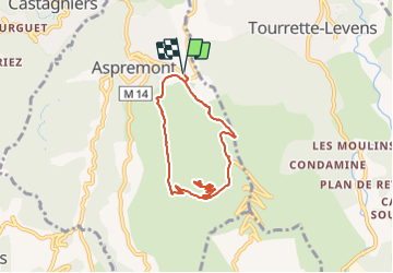
Trail Walking of 7.5 km to be discovered at Provence-Alpes-Côte d'Azur, Maritime Alps, Aspremont. This trail is proposed by jll7513.

Description

On se gare et on part d'en face la crèche les «poussins câlins ». Le début est pentu pendant 1,5 km. On monte au fort et curieusement au milieu des forêts d'antenne on peut y voir une vierge abriter sous un toit en tôle, on la voit sur une de mes photos. On revient à Aspremont en prenant une DFCI. Petite mais belle randonnée car les points de vue sont magnifiques d'abord sur la ville de Nice puis vers Antibes et enfin la vallée du Var avec les Alpes du sud en fond.

Elevation profile

Photos

Positioning

Country:
France
Region :
Provence-Alpes-Côte d'Azur
Department/Province :
Maritime Alps
Municipality :
Aspremont
Location:
Unknown
Start:(UTM)
359347 ; 4849194 (32T) N.

Comments

Please log in to post a review or rate the element


Merci pour le partage de cette belle randonnée.


Trails nearby

Trail Walking Aspremont - Vallon OBSCUR aux portes de Nice  - Photo
Walking
clarambre

Walking

Medium
(1)
Aspremont, Provence-Alpes-Côte d'Azur, Maritime Alps, France
5.4 km | 8.5 km-effort
3h 20min
Yes
Trail Running Aspremont - Tour des Monts d'Aspremont 2007 - Photo
Running
tracegps

Running

Very difficult
(2)
Aspremont, Provence-Alpes-Côte d'Azur, Maritime Alps, France
21 km | 33 km-effort
3h 0min
Yes
Trail Walking Tourrette-Levens - Tour Sud de Tourette Levens - Photo
Walking
Renefrt

Walking

Medium
Tourrette-Levens, Provence-Alpes-Côte d'Azur, Maritime Alps, France
8.1 km | 13 km-effort
5h 20min
Yes
Trail Walking Falicon - Pyramide de Nice Falicon - Photo
Walking
jll7513

Walking

Easy
Falicon, Provence-Alpes-Côte d'Azur, Maritime Alps, France
4 km | 6 km-effort
1h 7min
Yes
Trail Walking Saint-Blaise - st Blaise - Photo
Walking
Daniel Benteux

Walking

Difficult
Saint-Blaise, Provence-Alpes-Côte d'Azur, Maritime Alps, France
9.9 km | 16.1 km-effort
3h 26min
Yes
Trail Walking Saint-Blaise - St Blaise - Mont Inarte - Mont Cima  - Photo
Walking
clarambre

Walking

Difficult
Saint-Blaise, Provence-Alpes-Côte d'Azur, Maritime Alps, France
10.6 km | 19 km-effort
5h 0min
Yes
Trail Walking Carros - BALCON CARROS - Photo
Walking
Daniel Benteux

Walking

Very easy
Carros, Provence-Alpes-Côte d'Azur, Maritime Alps, France
13.6 km | 23 km-effort
4h 37min
Yes
Trail Walking Carros - tour des plans - Photo
Walking
Daniel Benteux

Walking

Easy
Carros, Provence-Alpes-Côte d'Azur, Maritime Alps, France
5.2 km | 8 km-effort
1h 43min
Yes
Trail Walking Aspremont - CIMA - Photo
Walking
Daniel Benteux

Walking

Easy
Aspremont, Provence-Alpes-Côte d'Azur, Maritime Alps, France
7.8 km | 13.4 km-effort
2h 43min
Yes


Close
My subscriptions