


vienne en val

skwick
User
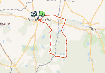

Length
12 km

Max alt
150 m

Uphill gradient
100 m
Km-Effort
13.4 km

Min alt
99 m

Downhill gradient
100 m
Boucle
Yes
Creation date :
2021-06-15 07:04:12.513
Updated on :
2021-06-15 09:38:06.399
2h33
Difficulty : Difficult

FREE GPS app for hiking
 SityTrail
IGN / Geographical institutes
SityTrail Plus
The world is yours!
About
Trail Walking of 12 km to be discovered at Centre-Loire Valley, Loiret, Vienne-en-Val. This trail is proposed by skwick.
Positioning
Country:
France
Region :
Centre-Loire Valley
Department/Province :
Loiret
Municipality :
Vienne-en-Val
Location:
Unknown
Start:(Dec)
Start:(UTM)
435339 ; 5294615 (31T) N.
Comments