fontaines la galoche rando du 15 06 2021

mimilolo
User
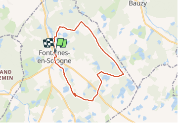

Length
14 km

Max alt
118 m

Uphill gradient
110 m
Km-Effort
15.5 km

Min alt
91 m

Downhill gradient
112 m
Boucle
Yes
Creation date :
2021-06-15 06:30:22.635
Updated on :
2021-06-15 13:39:05.366
2h51
Difficulty : Very easy

FREE GPS app for hiking
 SityTrail
IGN / Geographical institutes
SityTrail Plus
The world is yours!
About
Trail Walking of 14 km to be discovered at Centre-Loire Valley, Loir-et-Cher, Fontaines-en-Sologne. This trail is proposed by mimilolo.
Description
depart parking école belle rando à travers les étangs bien appréciée de tout le monde évite la route gardé leGR au début de la rando oblique à gauche
Positioning
Country:
France
Region :
Centre-Loire Valley
Department/Province :
Loir-et-Cher
Municipality :
Fontaines-en-Sologne
Location:
Unknown
Start:(Dec)
Start:(UTM)
390889 ; 5262937 (31T) N.
Comments