


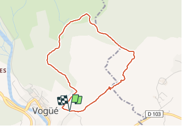
Saint Cerice - Tour du Ranc

pb07
User

Length
4.4 km

Max alt
265 m

Uphill gradient
51 m
Km-Effort
5.1 km

Min alt
217 m

Downhill gradient
50 m
Boucle
Yes
Creation date :
2021-06-16 07:48:45.034
Updated on :
2021-06-16 09:55:33.412
2h06
Difficulty : Easy

FREE GPS app for hiking
 SityTrail
IGN / Geographical institutes
SityTrail Plus
The world is yours!
About
Trail Walking of 4.4 km to be discovered at Auvergne-Rhône-Alpes, Ardèche, Vogüé. This trail is proposed by pb07.
Positioning
Country:
France
Region :
Auvergne-Rhône-Alpes
Department/Province :
Ardèche
Municipality :
Vogüé
Location:
Unknown
Start:(Dec)
Start:(UTM)
612778 ; 4933918 (31T) N.
Comments