


Tiranges Pont du diable Chalancon

psesjs
User
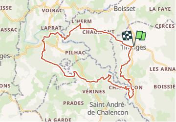

Length
21 km

Max alt
938 m

Uphill gradient
711 m
Km-Effort
30 km

Min alt
592 m

Downhill gradient
711 m
Boucle
Yes
Creation date :
2021-06-16 07:37:33.474
Updated on :
2021-06-16 15:15:08.56
5h25
Difficulty : Difficult

FREE GPS app for hiking
 SityTrail
IGN / Geographical institutes
SityTrail Plus
The world is yours!
About
Trail Walking of 21 km to be discovered at Auvergne-Rhône-Alpes, Haute-Loire, Tiranges. This trail is proposed by psesjs.
Positioning
Country:
France
Region :
Auvergne-Rhône-Alpes
Department/Province :
Haute-Loire
Municipality :
Tiranges
Location:
Unknown
Start:(Dec)
Start:(UTM)
577496 ; 5017179 (31T) N.
Comments