


Camp de César

rando30129
User
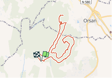

Length
11 km

Max alt
270 m

Uphill gradient
298 m
Km-Effort
14.9 km

Min alt
130 m

Downhill gradient
292 m
Boucle
Yes
Creation date :
2021-06-17 06:45:38.105
Updated on :
2021-06-20 12:26:02.303
2h20
Difficulty : Very easy

FREE GPS app for hiking
 SityTrail
IGN / Geographical institutes
SityTrail Plus
The world is yours!
About
Trail Walking of 11 km to be discovered at Occitania, Gard, Laudun-l'Ardoise. This trail is proposed by rando30129.
Positioning
Country:
France
Region :
Occitania
Department/Province :
Gard
Municipality :
Laudun-l'Ardoise
Location:
Unknown
Start:(Dec)
Start:(UTM)
631299 ; 4886045 (31T) N.
Comments