


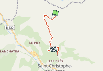
st Christophe Oisans

ascq
User

Length
5 km

Max alt
2645 m

Uphill gradient
125 m
Km-Effort
9.6 km

Min alt
1637 m

Downhill gradient
1005 m
Boucle
No
Creation date :
2021-06-17 08:01:56.316
Updated on :
2021-06-17 10:23:17.191
2h20
Difficulty : Medium

FREE GPS app for hiking
 SityTrail
IGN / Geographical institutes
SityTrail Plus
The world is yours!
About
Trail Walking of 5 km to be discovered at Auvergne-Rhône-Alpes, Isère, Saint-Christophe-en-Oisans. This trail is proposed by ascq.
Positioning
Country:
France
Region :
Auvergne-Rhône-Alpes
Department/Province :
Isère
Municipality :
Saint-Christophe-en-Oisans
Location:
Unknown
Start:(Dec)
Start:(UTM)
277226 ; 4984470 (32T) N.
Comments