


Passwang - Nunningenberg - Meltingenberg

doblerm
User
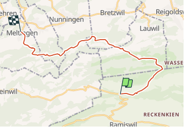

Length
12.6 km

Max alt
1168 m

Uphill gradient
350 m
Km-Effort
18.5 km

Min alt
589 m

Downhill gradient
718 m
Boucle
No
Creation date :
2014-12-11 00:00:00.0
Updated on :
2014-12-11 00:00:00.0
--
Difficulty : Unknown

FREE GPS app for hiking
 SityTrail
IGN / Geographical institutes
SityTrail Plus
The world is yours!
About
Trail Other activity of 12.6 km to be discovered at Solothurn, Bezirk Thal, Mümliswil-Ramiswil. This trail is proposed by doblerm.
Positioning
Country:
Switzerland
Region :
Solothurn
Department/Province :
Bezirk Thal
Municipality :
Mümliswil-Ramiswil
Location:
Unknown
Start:(Dec)
Start:(UTM)
398524 ; 5245996 (32T) N.
Comments