


2021-06-03T07-37-37Z

ajd26
User
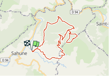

Length
11.6 km

Max alt
914 m

Uphill gradient
626 m
Km-Effort
19.9 km

Min alt
361 m

Downhill gradient
627 m
Boucle
Yes
Creation date :
2021-06-19 10:14:15.332
Updated on :
2021-06-19 10:18:30.068
--
Difficulty : Easy

FREE GPS app for hiking
 SityTrail
IGN / Geographical institutes
SityTrail Plus
The world is yours!
About
Trail Walking of 11.6 km to be discovered at Auvergne-Rhône-Alpes, Drôme, Sahune. This trail is proposed by ajd26.
Description
20210603 depart Sahune
Positioning
Country:
France
Region :
Auvergne-Rhône-Alpes
Department/Province :
Drôme
Municipality :
Sahune
Location:
Unknown
Start:(Dec)
Start:(UTM)
681125 ; 4920573 (31T) N.
Comments