


lurs

bouscaillou
User
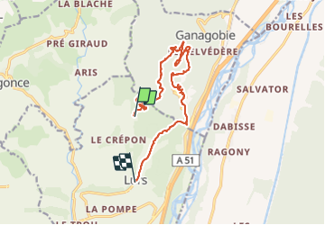

Length
15.2 km

Max alt
710 m

Uphill gradient
549 m
Km-Effort
22 km

Min alt
388 m

Downhill gradient
516 m
Boucle
No
Creation date :
2021-06-20 08:18:19.1
Updated on :
2021-06-20 15:21:32.186
6h59
Difficulty : Very difficult

FREE GPS app for hiking
 SityTrail
IGN / Geographical institutes
SityTrail Plus
The world is yours!
About
Trail Walking of 15.2 km to be discovered at Provence-Alpes-Côte d'Azur, Alpes-de-Haute-Provence, Lurs. This trail is proposed by bouscaillou.
Positioning
Country:
France
Region :
Provence-Alpes-Côte d'Azur
Department/Province :
Alpes-de-Haute-Provence
Municipality :
Lurs
Location:
Unknown
Start:(Dec)
Start:(UTM)
731724 ; 4874445 (31T) N.
Comments