


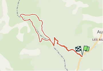
Le Marzenc (Auzet 04)

Clo0413
User

Length
11.9 km

Max alt
1931 m

Uphill gradient
803 m
Km-Effort
23 km

Min alt
1125 m

Downhill gradient
805 m
Boucle
Yes
Creation date :
2021-06-21 06:25:03.977
Updated on :
2024-09-20 06:03:45.759
6h42
Difficulty : Medium

FREE GPS app for hiking
 SityTrail
IGN / Geographical institutes
SityTrail Plus
The world is yours!
About
Trail Walking of 11.9 km to be discovered at Provence-Alpes-Côte d'Azur, Alpes-de-Haute-Provence, Auzet. This trail is proposed by Clo0413.
Positioning
Country:
France
Region :
Provence-Alpes-Côte d'Azur
Department/Province :
Alpes-de-Haute-Provence
Municipality :
Auzet
Location:
Unknown
Start:(Dec)
Start:(UTM)
284955 ; 4906912 (32T) N.
Comments