


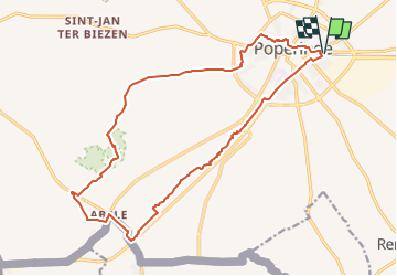
Rondje station Poperinge - Abele

FreddyTuerlinckx
User

Length
17.1 km

Max alt
66 m

Uphill gradient
109 m
Km-Effort
18.6 km

Min alt
16 m

Downhill gradient
108 m
Boucle
Yes
Creation date :
2021-06-22 08:47:33.506
Updated on :
2022-04-19 05:48:47.715
3h40
Difficulty : Easy

FREE GPS app for hiking
 SityTrail
IGN / Geographical institutes
SityTrail Plus
The world is yours!
About
Trail On foot of 17.1 km to be discovered at Flanders, West Flanders, Poperinge. This trail is proposed by FreddyTuerlinckx.
Positioning
Country:
Belgium
Region :
Flanders
Department/Province :
West Flanders
Municipality :
Poperinge
Location:
Poperinge
Start:(Dec)
Start:(UTM)
481418 ; 5633674 (31U) N.
Comments