


le Roc du Bougre

Mascart
User

Length
11.8 km

Max alt
749 m

Uphill gradient
573 m
Km-Effort
19.4 km

Min alt
312 m

Downhill gradient
572 m
Boucle
Yes
Creation date :
2021-06-22 06:39:27.862
Updated on :
2021-06-22 14:09:00.355
3h48
Difficulty : Medium

FREE GPS app for hiking
 SityTrail
IGN / Geographical institutes
SityTrail Plus
The world is yours!
About
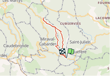
Trail Walking of 11.8 km to be discovered at Occitania, Aude, Mas-Cabardès. This trail is proposed by Mascart.
Description
départ entrée Mas Cabardes
via le Carnier A/R
puis la Cahusière
Combe de grill
ruisseau du Barthou
11kms/ 573 m/3h45
Positioning
Country:
France
Region :
Occitania
Department/Province :
Aude
Municipality :
Mas-Cabardès
Location:
Unknown
Start:(Dec)
Start:(UTM)
448728 ; 4801915 (31T) N.
Comments