


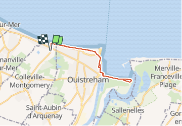
Colleville La Redoute AR

Roulland
User

Length
11.3 km

Max alt
8 m

Uphill gradient
66 m
Km-Effort
12.2 km

Min alt
0 m

Downhill gradient
66 m
Boucle
Yes
Creation date :
2021-06-23 08:02:37.655
Updated on :
2021-06-23 10:07:20.958
2h04
Difficulty : Easy

FREE GPS app for hiking
 SityTrail
IGN / Geographical institutes
SityTrail Plus
The world is yours!
About
Trail Walking of 11.3 km to be discovered at Normandy, Calvados, Colleville-Montgomery. This trail is proposed by Roulland.
Positioning
Country:
France
Region :
Normandy
Department/Province :
Calvados
Municipality :
Colleville-Montgomery
Location:
Unknown
Start:(Dec)
Start:(UTM)
697545 ; 5463237 (30U) N.
Comments