


Cret de Chalam

geoffrayLayeux
User
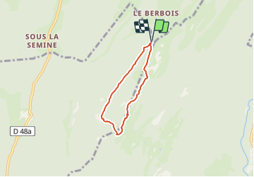

Length
4.4 km

Max alt
1522 m

Uphill gradient
240 m
Km-Effort
7.6 km

Min alt
1271 m

Downhill gradient
243 m
Boucle
Yes
Creation date :
2021-06-23 16:02:09.188
Updated on :
2021-06-23 16:03:06.686
1h43
Difficulty : Easy

FREE GPS app for hiking
 SityTrail
IGN / Geographical institutes
SityTrail Plus
The world is yours!
About
Trail On foot of 4.4 km to be discovered at Auvergne-Rhône-Alpes, Ain, Champfromier. This trail is proposed by geoffrayLayeux.
Positioning
Country:
France
Region :
Auvergne-Rhône-Alpes
Department/Province :
Ain
Municipality :
Champfromier
Location:
Unknown
Start:(Dec)
Start:(UTM)
721067 ; 5127485 (31T) N.
Comments