


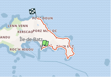
Tour de l’île de Batz

Derrendinger
User

Length
4.9 km

Max alt
26 m

Uphill gradient
56 m
Km-Effort
5.6 km

Min alt
0 m

Downhill gradient
45 m
Boucle
No
Creation date :
2021-06-23 10:14:24.0
Updated on :
2021-06-23 16:54:48.514
1h36
Difficulty : Very easy

FREE GPS app for hiking
 SityTrail
IGN / Geographical institutes
SityTrail Plus
The world is yours!
About
Trail Walking of 4.9 km to be discovered at Brittany, Finistère, Île-de-Batz. This trail is proposed by Derrendinger.
Positioning
Country:
France
Region :
Brittany
Department/Province :
Finistère
Municipality :
Île-de-Batz
Location:
Unknown
Start:(Dec)
Start:(UTM)
425921 ; 5399131 (30U) N.
Comments