


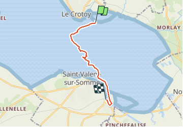
Baie de Somme - traversée

raymondfn
User

Length
7 km

Max alt
7 m

Uphill gradient
19 m
Km-Effort
7.3 km

Min alt
0 m

Downhill gradient
15 m
Boucle
No
Creation date :
2021-06-23 14:13:20.0
Updated on :
2021-06-23 17:14:34.779
3h01
Difficulty : Medium

FREE GPS app for hiking
 SityTrail
IGN / Geographical institutes
SityTrail Plus
The world is yours!
About
Trail Walking of 7 km to be discovered at Hauts-de-France, Somme, Favières. This trail is proposed by raymondfn.
Positioning
Country:
France
Region :
Hauts-de-France
Department/Province :
Somme
Municipality :
Favières
Location:
Unknown
Start:(Dec)
Start:(UTM)
402776 ; 5563221 (31U) N.
Comments