


Villeneuve Loubet -Marquisat

papajp
User
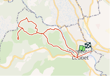

Length
11.5 km

Max alt
191 m

Uphill gradient
309 m
Km-Effort
15.6 km

Min alt
12 m

Downhill gradient
295 m
Boucle
No
Creation date :
2021-06-24 06:15:28.0
Updated on :
2021-06-26 01:28:21.846
3h39
Difficulty : Very easy

FREE GPS app for hiking
 SityTrail
IGN / Geographical institutes
SityTrail Plus
The world is yours!
About
Trail Walking of 11.5 km to be discovered at Provence-Alpes-Côte d'Azur, Maritime Alps, Villeneuve-Loubet. This trail is proposed by papajp.
Description
Très facile mais surtout pas l’été trop chaut
Photos


Positioning
Country:
France
Region :
Provence-Alpes-Côte d'Azur
Department/Province :
Maritime Alps
Municipality :
Villeneuve-Loubet
Location:
Unknown
Start:(Dec)
Start:(UTM)
348440 ; 4835571 (32T) N.
Comments